During the development of the Wellington Region airspace maps for Remotely Piloted Aircraft (RPAS) I knew that I would need to create some zones around various features where remotely piloted aircraft would be excluded from flying. These would include zones extending 4km outwards from the perimeter of an aerodrome or registered helipad and also some smaller exclusion zones around picnic areas and buildings on public lands. The local regional council who were interested in this GIS exercise very kindly provided me with GIS layers that marked the public land they were responsible for and layers with features of interest such as ecologically sensitive areas, the locations of picnic tables, and buildings on their land. From these layers I could generate the necessary exclusion zones.
Initially I was a little daunted by the idea that I would have to write a python script to generate some GPS coordinates around the various features which I would then import into QGIS. Luckily realistic thinking took over and dispelled my daft thoughts of trying to write code for this. I reasoned that creating zones around features on GIS maps must surely be a common activity so there must be a tool for it. I soon discovered the Buffer tool under the Geoprocessing Tools option in the Vector menu.
So here is the method I used for generating 4km buffer zones around all Aerodromes in the region using the Buffer Tool.
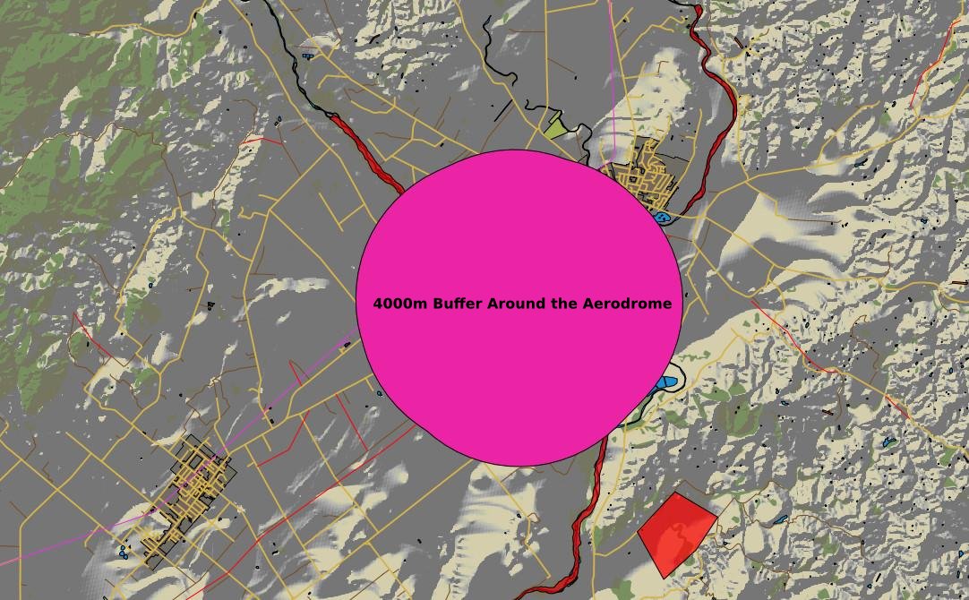
To illustrate this here is an image showing the Masterton Aerodrome. The perimeter of the Aerodrome is an unusual shape so it will help demonstrate that the buffer created is based on the perimeter rather than the centre of the feature. We need to create a 4km buffer zones around it. The Aerodrome layer includes the Airports in Wellington and Paraparaumu. By calculating a buffer for the layer containing the Masterton Aerodrome I will also generate buffer zones around the other airports in the same operation. Had I not wanted to do this and just have the buffer zone around the Masterton Aerodrome I would need to select the Masterton Aerodrome feature at this point in the process.

To find the Buffer Tool, access it through the top bar menu Vector»Geoprocessing Tools» Buffer(s).

You will be faced with the following dialogue.
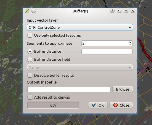
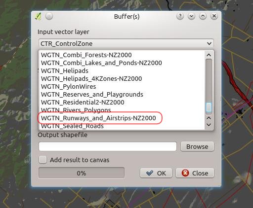
Select the layer you would like to create a buffer around from the Input Vector Layer drop down. It is worth nothing that the Buffer Tool works on point and line layers as well as polygon layers.
Once you have the layer selected, set up the resolution of the buffer shape, the buffer distance and the where you want to save the shape created by this process.

“Segments to approximate” is a measure of the resolution of the buffer shape that will be generated. It is a matter of taste or purpose what this is set to. I found the default of 5 to be a bit coarse for my liking.
The buffer distance is the distance in the map’s units which in this case are metres. Some other coordinate reference systems may use angle instead.
If you want to add the result to your map straight away, just tick the “Add Result to Canvas” option.
Other things of note in this dialogue are the “Use only Selected Features” tick box and the “Dissolve Buffer Results” tick box. The former allows you to add a buffer around only one feature or a selected few features on a layer, while the latter joins resulting overlapping buffer zones into one feature.
Click OK and the new layer will be calculated, saved as a new shape file in the location you have specified and added to the canvas if you have ticked that option. When done you can close the dialogue.
We now have a large blob over the Masterton Aerodrome. The edge of this is 4km from the perimeter of the Aerodrome. Because the Masterton Aerodrome feature was not a regular shape the calculated buffer is an uneven shape.